

The National Weather Service has continued the Coastal Flood Warning for the Borough of Avalon through Sunday at 6:00pm for the possibility of moderate coastal flooding at time of high tide. The Wind Advisory remains in effect through Saturday at 6:00pm for winds gusting to 50mph.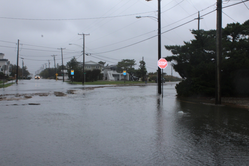
A coastal storm that has brought plenty of wind, rain, and coastal flooding to our region continues to impact the Borough. It is possible that moderate coastal flooding could again impact our region during the next three high tide cycles, especially on Saturday afternoon. We experienced moderate coastal flooding during high tide Friday afternoon, and again during our overnight hours earlier this morning. Areas of concern for coastal flooding include but are not limited to portions of Dune Drive in the business district; portions of Ocean Drive; the roadway leading to the Townsend’s Inlet Bridge and nearby communities; Bay Park Marina; and other areas.
Here are the high tides for the weekend at the Townsend’s Inlet Bridge between Avalon and Sea Isle City: Saturday, 12:58pm; Sunday, 1:35am and 2:02pm; Monday, 2:43am and 3:07pm. High winds may cause power outages in our region as well. If you experience a power outage, report it to Atlantic City Electric immediately at 1-800-833-7476. Report any downed power wires to that number as well.
The Avalon Office of Emergency Management offers these common sense safety tips to keep in mind during coastal storms like these:
–Never drive on any flooded street or flooded intersection. You put yourself and others at risk, and also threaten your personal vehicle and other property from the wake caused by driving on a flooded street. Water is commonly deeper than it appears to be on a street and in an intersection. Safely avoid driving on any street with water on it during a storm event.
–Always move your car out of areas prone to flooding to higher ground. Our next high tide will be during the overnight hours and we expect moderate coastal flooding.
–Secure all outdoor objects including trash cans and lawn furniture.
–Beaches will experience erosion during this storm resulting in unsafe walking conditions and a high surf.
Here are the texts of the Coastal Flood Warning and the High Wind Advisory from the National Weather Service:
… Coastal Flood Warning remains in effect until 6 PM EDT
Sunday…
* coastal flooding… widespread moderate tidal flooding will
occur through multiple successive high tide cycles through
this weekend. Tides through the weekend will likely be similar
to the Friday high tide levels. A building surge into Saturday
combined with 6 to 10 foot breaking waves and periods of
moderate rain will contribute to the tidal inundation
flooding. Major tidal flooding is expected in many of the back
bays and also along the Atlantic coast in Kent and Sussex
counties in Delaware.
* Timing… today’s high tide will occur in the early afternoon.
High tide on the back bays and along the Raritan Bay occurs
later than the high tide on the oceanfront.
* Impacts… numerous roadways will flood. Minor to moderate
property damage is possible. The Tides and wave action will
probably result in moderate beach erosion.
Precautionary/preparedness actions…
Take appropriate action to protect life and property. Follow the
recommendations of local emergency management officials. Be sure
to check the latest forecast from time to time.
Location time of predicted water level
high tide
Sandy Hook… NJ 1249 PM Sat near 8.0 feet MLLW
(sandy hook bay)146 PM sun 7.5 to 8.0 feet MLLW
Seaside Heights… NJ 1219 PM Sat near 8.0 feet MLLW
(oceanfront) 116 PM sun 7.5 to 8.0 feet MLLW
Atlantic City… NJ 1224 PM Sat around 7.5 feet MLLW
(oceanfront) 127 PM sun around 7.0 feet MLLW
Cape May… NJ 1258 PM Sat around 8.0 feet MLLW
(oceanfront) 135 am sun 7.5 to 8.0 feet MLLW
201 PM sun around 8.0 feet MLLW
Lewes… de 138 PM Sat around 8.0 feet MLLW
(delaware bay) 212 am sun 7.5 to 8.0 feet MLLW
239 PM sun around 8.0 feet MLLW
Rehoboth Beach… de 1239 PM Sat around 7.5 feet MLLW
(oceanfront) 103 am sun 7.5 to 8.0 feet MLLW
139 PM sun around 8.0 feet MLLW
Precautionary/preparedness actions…
A coastal Flood Warning means that moderate or major tidal
flooding is occurring or imminent. Be prepared for rising water
levels and take appropriate action to protect life and property.
Follow the recommendations of local emergency management
officials.
Do not drive your vehicle through flood waters. The water may be
deeper than you think it is. You will be putting yourself in
danger and your vehicle may be damaged… leading to costly
repairs.
For a list of the impact of different tide heights in your County
please visit www.Erh.NOAA.Gov/phi/tides.Htm (all in lower case)
Wind Advisory
Statement as of 3:48 AM EDT on October 03, 2015
… Wind Advisory remains in effect until 6 PM EDT this evening…
* locations… locations within a few miles of the New Jersey and
Delaware shore.
* Winds… northeast 25 to 35 mph with gusts up to 50 mph.
* Timing… today.
* Impacts… caution is urged for high profile vehicles traveling
on bridges and overpasses. Limbs will be knocked down and
cause isolated power outages. Blowing sand may cover some
coastal roads.
Precautionary/preparedness actions…
A Wind Advisory means that very windy conditions are expected
Friday. Winds this strong can make driving difficult… especially
for high profile vehicles. Use extra caution. Light-weight
outdoor objects such as patio furniture and garbage cans should
be secured.
