

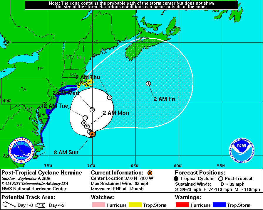
The National Weather Service has continued the Tropical Storm Warning for the entire coastline of New Jersey, including the Borough of Avalon. The Tropical Storm Warning remains in effect as Hermine continues to meander in the North Atlantic away from the New Jersey coastline. The storm is expected to increase in strength and become a Category One hurricane. The effects of the storm will still be felt in Avalon as gusty winds, beach erosion, rough surf, strong rip currents, and coastal flooding at times of high tide remains present.
As of Sunday morning, strong rip currents were present on the beachfront with six to eight foot rolling waves. There has been beach erosion in the north end of our community that was fortified by the Avalon Department of Public Works with a sand back passing project in the Spring. Observe all warnings provided by the Avalon Beach Patrol.
Winds Sunday afternoon and Sunday evening will be out of the northeast at 25-35mph with gusts to 40mph. Rain showers are possible later in the day.
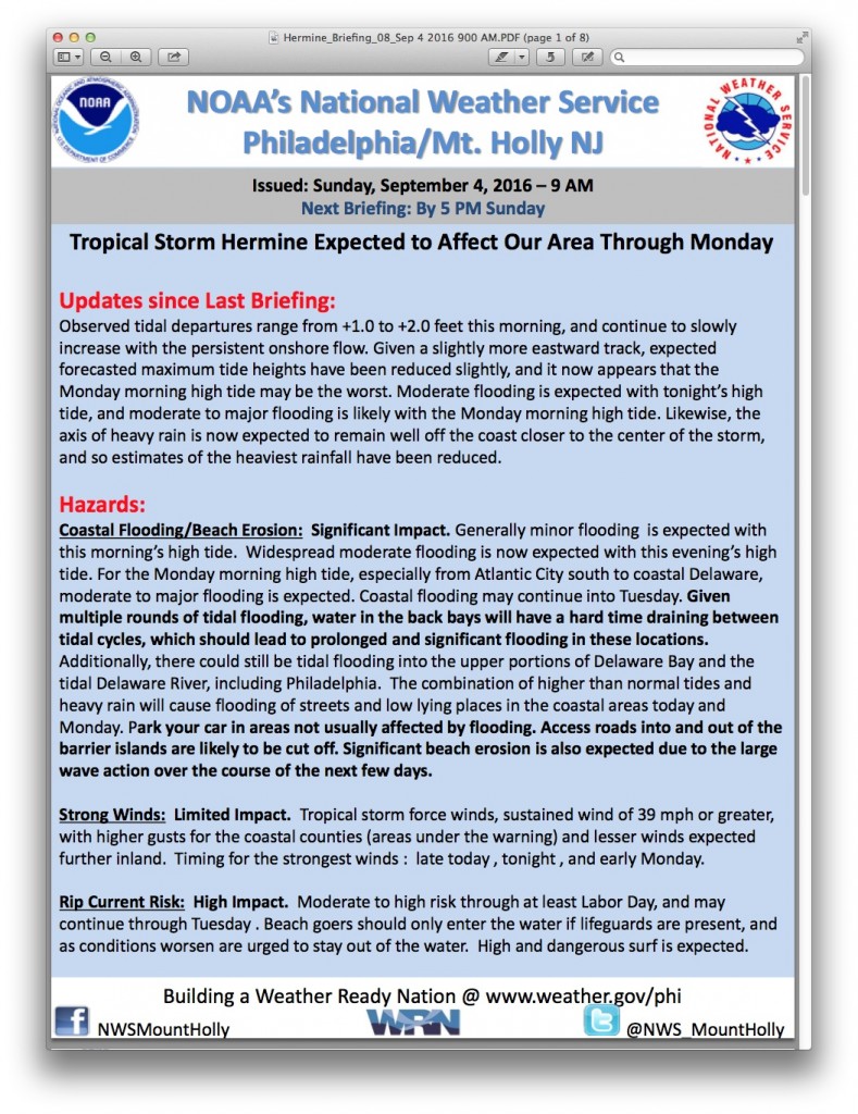
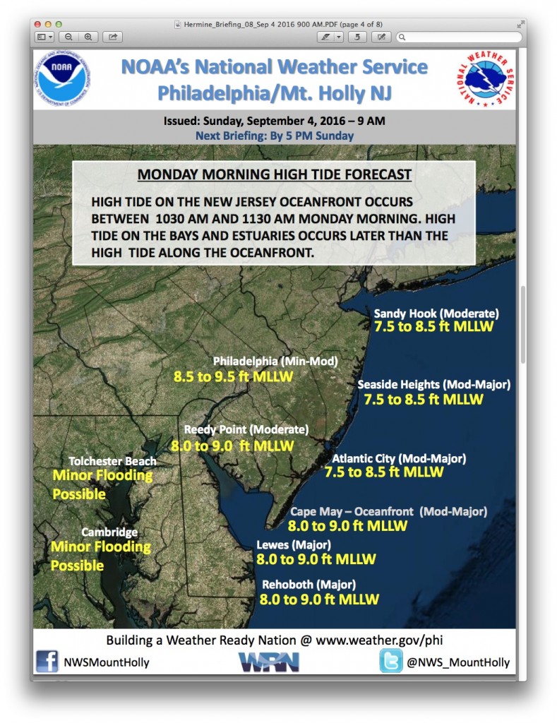
The briefing provided by the National Weather Service on Sunday, September 4th, at 9:00am shows generally minor coastal flooding during time of high tide Sunday morning. Widespread moderate coastal flooding is forecast during time of high tide on Sunday evening. Moderate to potentially major tidal flooding is forecast for the Monday morning high tide. The storm may jog slightly closer to the coastline later today which could aggravate any flooding situation.
High tide at the Townsend’s Inlet Bridge will occur Sunday at 11:14am, and again at 11:25pm. High tide on Monday will occur at 11:53am. Visitors to the Borough should be aware that driving on some main streets may become difficult or impossible during times of high tide Sunday evening and Monday morning. It is wise to plan your commute home a few hours before or after these high tide events. If you live in an area of Avalon that typically floods during coastal storm events, consider moving your vehicle off the street. Never park your vehicle on any bridge in our community as larger emergency vehicles, including fire trucks, are blocked by vehicles parked on bridges. Never attempt to drive on any flooded street as this puts you at risk, and salt water will damage your vehicle. Driving on a flooded street also creates an unnecessary wake that can damage vehicles/property owned by others.
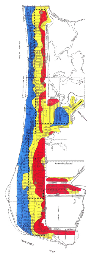
Here is a map of Avalon that shows areas that are prone to flooding in RED:
Continue to secure any objects that are prone to strong winds including trash cans and patio umbrellas. The Avalon Free Public Library, Avalon Community Hall and recreation facilities, the Avalon History Center, and Avalon Borough Hall are closed on Sunday and Monday. Refrain from placing bulk trash curbside until the wind/flooding threat subsides; bulk trash will be collected curbside in Avalon starting on Monday, September 12th. If you have any emergency, dial 911. If you are home and see flooding in your street, it is best to shelter in your home until flood waters recede.
The Borough continues to be in contact with our partners at the Cape May County Office of Emergency Management and the New Jersey State Police. The Borough will participate in a meeting with Cape May County OEM at 11:00am today. Continue to follow advisories regarding this storm event on www.avalonemergency.org. Avalon will initiate a Code Red emergency alert call to the public when necessary.
