The National Weather Service has continued the Coastal Flood Warning for the Borough of Avalon until Wednesday, September 20th, at 1:00am. Avalon and other coastal communities may experience moderate coastal flooding at time of high tide Tuesday evening, which occurs at 8:19pm at the Townsend’s Inlet Bridge.
Hurricane Jose continues to track in the North Atlantic well off the coast of New Jersey. The storm is expected to remain several hundred miles off the coast of New Jersey for the next few to several days. Showers, rain, and gusty winds are expected to diminish. However, moderate coastal flooding remains a risk for this evening’s high tide event.
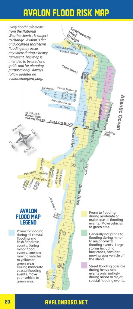
Never attempt to drive on any flooded street or through any flooded intersection. If you live in an area of Avalon that is subject to street flooding during moderate coastal flooding events, consider moving your car off the street or to another section of Avalon that typically does not flood during moderate flooding.
Avalon has prepared a flood risk map for planning and advisory purposes.
The Avalon Police Department may have to close the road leading to the Townsend’s Inlet Bridge if wave action on the roadway or flooding is a concern. Be prepared to take an alternate route if the road needs to be closed Tuesday evening.
Here is the text of the Coastal Flood Warning, continued by the National Weather Service:
Coastal Flood Warning, High Surf Advisory
Issued: 2:04 PM EDT Sep. 19, 2017 – National Weather Service
… Coastal Flood Warning remains in effect until 1 am EDT
Wednesday…
… High surf advisory remains in effect until 6 PM EDT this
evening…
* location… coastal areas of New Jersey and Delaware.
* Coastal flooding… moderate flooding is anticipated with high
tide this evening.
* Timing… high tide on the New Jersey and Delaware oceanfront
occurs between 7:30 PM and 8:30 PM this evening. High tide on
the back bays occurs later than the high tide on the oceanfront.
* Surge… 1.5 to 2.5 feet above astronomical tide.
* Waves… large breaking waves of 8 to 11 feet along the coast.
* Rip currents… there is a high risk for the development of rip
currents.
* Coastal flooding impacts… widespread roadway flooding is
expected and minor property damage is possible, especially
around high tide this evening.
* Surf and rip current impacts… significant beach erosion,
localized dune overwash and minor damage to piers have already
been reported today. Dangerous and potentially life threatening
conditions will exist for those who decide to enter the surf
zone.
* Outlook… the potential for minor coastal flooding near times of
high tide and a high risk of rip currents will continue into
Wednesday and possibly Thursday.
Precautionary/preparedness actions…
A high surf advisory means that high surf will affect beaches in
the advisory area… producing beach erosion and dangerous
swimming conditions.
A coastal Flood Warning means that flooding is occurring or
imminent. Coastal residents in the warned area should be alert
for rising water… and take appropriate action to protect life
and property.
Do not drive your vehicle through flood waters. The water may be
deeper than you think it is. You will be putting yourself in
danger and your vehicle may be damaged… leading to costly
repairs.
For a list of the impact of different tide heights in your County
please visit www.Weather.Gov/phi/tides


