The National Weather Service has continued a Flash Flood watch for the Borough and all of South Jersey. The Watch is in effect from Sunday, June 10th at 6:00pm through Monday morning, June 11th. The Watch means conditions are favorable for showers and thunderstorms, along with the potential for heavy downpours, much like we experienced through the day on Saturday which produced street flooding in some areas of our community.
If you hear thunder or see lightning, seek shelter immediately. Never attempt to drive on any street that is flooded as this puts you or your vehicle at risk. Street flooding is always deeper than it appears. There is the potential for 1-2 inches of rain during this second weekend round of rain; on Saturday, three inches of rain fell in our area.
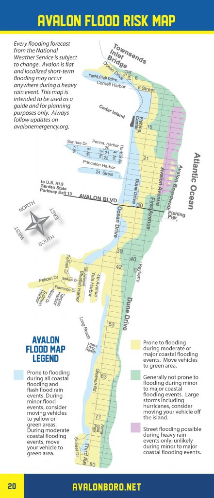
The Borough of Avalon has developed a flood risk map for coastal flooding and heavy rainfall events for guidance purposes.
Here is the text of the Flash Flood Watch issued by the National Weather Service:
Flash Flood Watch
Flood Watch National Weather Service Mount Holly NJ 1057 AM EDT Sun Jun 10 2018 DEZ001>004-MDZ008-012-015-019-020-NJZ016>027-PAZ070-071-101>104- 102300- /O.CON.KPHI.FF.A.0005.180610T2200Z-180611T1200Z/ /00000.0.ER.000000T0000Z.000000T0000Z.000000T0000Z.OO/ New Castle-Kent-Inland Sussex-Delaware Beaches-Cecil-Kent MD- Queen Annes-Talbot-Caroline-Salem-Gloucester-Camden- Northwestern Burlington-Ocean-Cumberland-Atlantic-Cape May- Atlantic Coastal Cape May-Coastal Atlantic-Coastal Ocean- Southeastern Burlington-Delaware-Philadelphia-Western Chester- Eastern Chester-Western Montgomery-Eastern Montgomery- Including the cities of Wilmington, Dover, Georgetown, Rehoboth Beach, Elkton, Chestertown, Centreville, Easton, Denton, Pennsville, Glassboro, Camden, Cherry Hill, Moorestown, Mount Holly, Jackson, Millville, Hammonton, Cape May Court House, Ocean City, Atlantic City, Long Beach Island, Wharton State Forest, Media, Philadelphia, Honey Brook, Oxford, West Chester, Kennett Square, Collegeville, Pottstown, Norristown, and Lansdale 1057 AM EDT Sun Jun 10 2018 ...FLASH FLOOD WATCH REMAINS IN EFFECT FROM 6 PM EDT THIS EVENING THROUGH MONDAY MORNING... The Flash Flood Watch continues for * Portions of Delaware, northeast Maryland, southern New Jersey, and southeast Pennsylvania, including the following areas, in Delaware, Delaware Beaches, Inland Sussex, Kent, and New Castle. In northeast Maryland, Caroline, Cecil, Kent MD, Queen Annes, and Talbot. In southern New Jersey, Atlantic, Atlantic Coastal Cape May, Camden, Cape May, Coastal Atlantic, Coastal Ocean, Cumberland, Gloucester, Northwestern Burlington, Ocean, Salem, and Southeastern Burlington. In southeast Pennsylvania, Delaware, Eastern Chester, Eastern Montgomery, Philadelphia, Western Chester, and Western Montgomery. * From 6 PM EDT this evening through Monday morning. * Light to moderate rainfall will develop across the area this afternoon. The rainfall is expected to become heavier later this evening into the overnight hours. A total of 1 to 2 inches of rain are expected across portions of the area. Some thunderstorms may also occur and could be slow moving which could lead to locally higher amounts. * Excessive rainfall within a short period of time can lead to rapidly rising waters and flash flooding, particularly in urban areas and along small creeks and streams. PRECAUTIONARY/PREPAREDNESS ACTIONS... A Flash Flood Watch means that there is the potential for flash flooding which can be life-threatening. Heavy rain is expected to occur over a short period of time. Rapidly rising flood waters may quickly inundate roadways and areas of poor drainage. Streams and creeks could leave their banks, flooding nearby properties. Please monitor the forecast, especially if you live in a location that is prone to flooding. Be prepared to take action if a flash flood warning is issued for your area.


