

The National Weather Service has issued a Flash Flood Watch for Avalon and other communities along the Jersey Shore. The Watch is in effect from Saturday afternoon through late Saturday night, July 21st. The Watch means that a few inches of rainfall are possible which could cause some street flooding in a very short period of time.
A low pressure system will form just off the coastline of New Jersey on Saturday. This system may bring showers, thunderstorms with heavy rain, and gusty winds through the afternoon and evening hours on Saturday. Rain may fall very heavy in a short period of time which may cause street flooding throughout our community. There are sections of Avalon where this heavy rainfall may produce widespread street flooding, including the north end beach blocks and along sections of Dune Drive.
Never attempt to drive your car on any flooded street as this puts you and your vehicle at risk. Water is always deeper than it appears to be in the street. If you live on a street that typically floods during rainstorm events, consider moving your vehicle to another portion of Avalon that is not prone to street flooding during heavy rainfall events. Coastal flooding is not expected; this storm is expected to produce street flooding from heavy rainfall.
Avalon has produced a flood risk map that shows the areas of our community that may be impacted by heavy rainfall events. Please use this map as a guide for planning purposes.
![]()
Follow all instructions provided by the Avalon Beach Patrol over the weekend; always swim in the presence of a lifeguard. Continue to follow the forecast on traditional media outlets. Avalon may implement a Reverse 911 phone call Saturday morning if the forecast remains the same, or worsens.
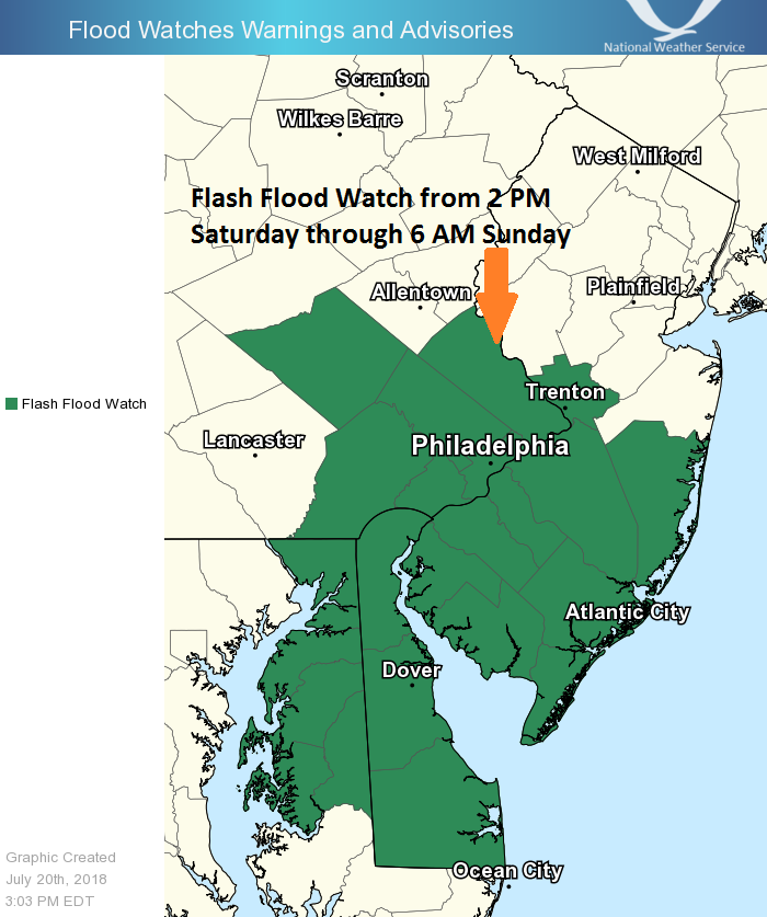
Here is the text of the Flash Flood Watch issued for Avalon by the National Weather Service:
Flash Flood Watch
Flood Watch National Weather Service Mount Holly NJ 244 PM EDT Fri Jul 20 2018
FLASH FLOOD WATCH IN EFFECT FROM SATURDAY AFTERNOON THROUGH LATE SATURDAY NIGHT…
The National Weather Service in Mount Holly has issued a * Flash Flood Watch for portions of Delaware, northeast Maryland, New Jersey, and Pennsylvania, including the following areas, in Delaware, Delaware Beaches, Inland Sussex, Kent, and New Castle. In northeast Maryland, Caroline, Cecil, Kent MD, Queen Annes, and Talbot. In New Jersey, Atlantic, Atlantic Coastal Cape May, Camden, Cape May, Coastal Atlantic, Coastal Ocean, Cumberland, Gloucester, Mercer, Northwestern Burlington, Ocean, Salem, and Southeastern Burlington. In Pennsylvania, Berks, Delaware, Eastern Chester, Eastern Montgomery, Lower Bucks, Philadelphia, Upper Bucks, Western Chester, and Western Montgomery.
* From Saturday afternoon through late Saturday night * Rain…heavy at times…is expected to overspread the area from south to north Saturday afternoon and evening. Rainfall rates over one inch per hour are possible.
* Excessive rainfall within a short period of time can lead to rapidly rising water and flash flooding, particularly in urban areas and along small creeks and streams.
PRECAUTIONARY/PREPAREDNESS ACTIONS… A Flash Flood Watch means that there is the potential for flash flooding which can be life-threatening. Heavy rain is expected to occur over a short period of time. Rapidly rising flood waters may quickly inundate roadways and areas of poor drainage. Streams and creeks could leave their banks, flooding nearby properties. Please monitor the forecast, especially if you live in a location that is prone to flooding. Be prepared to take action if a flash flood warning is issued for your area.
