The National Weather Service has issued a Flash Flood Watch for coastal areas of southern New Jersey from Thursday afternoon through late Thursday night. It is possible that our region may receive two to three inches of rain, with higher amounts possible as the remnants of Hurricane Michael veer away from the eastern seaboard into the North Atlantic.
Showers are expected to develop Thursday afternoon with the potential for heavy rainfall Thursday night into early Friday morning. The track of Michael will determine how much rain falls in our area. Please be advised that travel conditions due to street flooding and low visibility may be difficult Thursday night. The passage of the storm may produce windy conditions; now is a good time to secure any loose objects including trash cans and patio furniture.
Never attempt to drive on any flooded street or intersection as this can put you and your vehicle at risk, and create an unnecessary wake that may damage private and public property. Continue to monitor traditional media outlets for updates to the forecast in the event a warning is necessary.
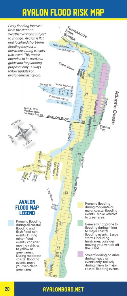
The Borough of Avalon has developed a flood risk map that delineates the areas of our community that may flood during heavy rainfall events. You may consider moving your vehicle to another location of the Borough. Tidal flooding is not expected. A reminder: The Townsend’s Inlet Bridge continues to be closed for planned maintenance activity.
Here is the context of the Flash Flood Watch issued by the National Weather Service:
Flash Flood Watch
Flood Watch…CORRECTED National Weather Service Mount Holly NJ 321 PM EDT Wed Oct 10 2018
FLASH FLOOD WATCH IN EFFECT FROM THURSDAY AFTERNOON THROUGH LATE THURSDAY NIGHT…
The National Weather Service in Mount Holly has issued a * Flash Flood Watch for Delaware, Northeastern Maryland, Central and Southern New Jersey and far Southeastern Pennsylvania, including the Interstate-95 corridor. * From Thursday afternoon through late Thursday night * Showers producing moderate to heavy rainfall will develop Thursday afternoon, and then will continue into early Friday morning. Rainfall totals of 2 to 3 inches, with locally higher amounts, will fall during this time. * The heaviest rain will fall across portions of Delmarva and the Coastal Plain of New Jersey. The Interstate-95 corridor is also susceptible to heavy rain and flash flooding. Flash flooding is expected on roadways and in areas of poor drainage. Minor flooding along small streams and creeks is possible as well.
PRECAUTIONARY/PREPAREDNESS ACTIONS… A Flash Flood Watch means that there is the potential for flash flooding which can be life-threatening. Heavy rain is expected to occur over a short period of time. Rapidly rising flood waters may quickly inundate roadways and areas of poor drainage. Streams and creeks could leave their banks, flooding nearby properties. Please monitor the forecast, especially if you live in a location that is prone to flooding. Be prepared to take action if a flash flood warning is issued for your area.


