

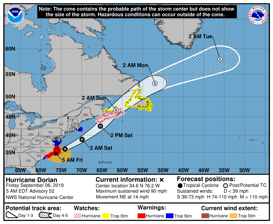
The National Weather Service has issued a Coastal Flood Advisory, a Rip Current statement, and a High Surf Advisory for the southern New Jersey coastline. These weather advisories are a result of Hurricane Dorian which impacted the North Carolina coast on Friday morning and is expected to move further out to sea later today.
The impact to our region will be the potential for minor coastal flooding at time of high tide on Friday afternoon. High tide will occur at the Townsend’s Inlet Bridge at 3:55pm. Do not attempt to drive on a street that is impacted by flooding. Showers and windy conditions are possible today with wind gusts approaching 39mph. Secure any outdoor objects that are prone to high winds.
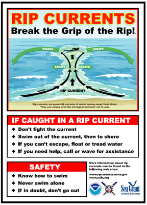
Rip currents will be in the ocean today and likely on Saturday. Never enter the ocean unless you are in the presence of a lifeguard. Obey all instructions provided lifeguards. Many beaches are not guarded this week, into the weekend.
Rough surf is expected today and possibly Saturday. Beach erosion is possible.
Here is the text of the various advisories issued by the National Weather Service on Friday, September 6th, 2019:
High Surf Advisory
Coastal Hazard Message
National Weather Service Mount Holly NJ
320 AM EDT Fri Sep 6 2019
Delaware Beaches-Atlantic Coastal Cape May-Coastal Atlantic-
320 AM EDT Fri Sep 6 2019
…HIGH RIP CURRENT RISK REMAINS IN EFFECT THROUGH THIS EVENING…
…COASTAL FLOOD ADVISORY IN EFFECT FROM 1 PM THIS AFTERNOON TO
7 PM EDT THIS EVENING…
…HIGH SURF ADVISORY REMAINS IN EFFECT FROM 2 PM THIS AFTERNOON
TO 10 AM EDT SATURDAY…
The National Weather Service in Mount Holly has issued a Coastal
Flood Advisory, which is in effect from 1:00 PM this afternoon
until 7:00 PM this evening.
* LOCATIONS…Coastal areas of Atlantic County and Cape May
County in New Jersey, and coastal areas of Sussex County in
Delaware.
* TIMING…From today into Saturday morning.
* COASTAL FLOOD IMPACTS…Up to one foot of inundation above
ground level is possible in low-lying areas near shorelines and
tidal waterways. Localized roadway flooding is expected. Some
roads may be closed due to high water.
* SURF ZONE IMPACTS…6 to 10 foot breaking waves and very strong
rip currents will be a life-threatening danger to anyone who
enters the surf.
PRECAUTIONARY/PREPAREDNESS ACTIONS…
A High Surf Advisory means that high surf will produce localized
beach erosion and dangerous swimming conditions.
Stay out of the surf. If you are ever caught in a rip current,
relax and float. Do not swim against the current. If possible,
swim in a direction following the shoreline. If unable to escape,
face the shore and call or wave for help.
A Coastal Flood Advisory means that minor tidal flooding is
expected. Minor tidal flooding often results in some road
closures. Usually, the most vulnerable roadways will flood.
Do not leave your vehicle at a location that is prone to tidal
flooding. Do not drive your vehicle through flood waters. The
water may be deeper than you think it is. You will be putting
yourself in danger and your vehicle may be damaged, leading to
costly repairs.
