

National Weather Service Weather Briefing for Coastal Flood Warning October 10-12
The National Weather Service has issued a Coastal Flood Warning for the Borough of Avalon for a coastal flooding event that is expected to last until early Saturday morning. Moderate coastal flooding is expected during times of high tide for this event. Residents are advised to exercise caution while driving and to never drive on a flooded street or through a flooded intersection. Driving on a flooded street also causes a wake that can damage private and public property.
Here are the times for high tide for the next three days when street flooding is anticipated: Thursday, 6:48pm; Friday, 7:15am and 7:27pm; and Saturday, 7:50am and 8:04pm. Avalon has issued a flood advisory map that depicts general areas of flooding during these events. If you live on a street prone to flooding, consider moving your vehicle to another part of the community that does not typically flood, especially during times of high tide.
![]()
At times, the Avalon Police Department may have to close the access road to the Townsend’s Inlet Bridge due to unsafe travel conditions. Pay attention to the bridge warning signs located on Ocean Drive heading north towards the bridge.
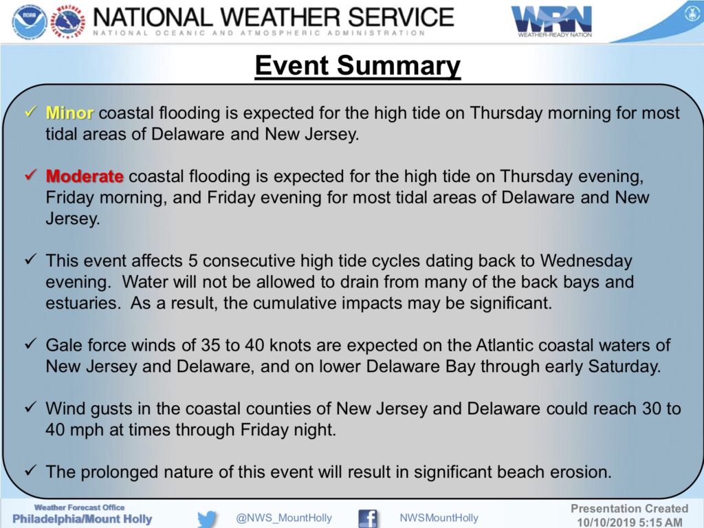
Here is the text of the Coastal Flood Warning issued through Saturday, October 12th, from the National Weather Service:
Coastal Flood Warning
Coastal Hazard Message National Weather Service Mount Holly NJ 410 AM EDT Thu Oct 10 2019 …LONG DURATION COASTAL FLOOD EVENT EXPECTED THROUGH FRIDAY… …COASTAL FLOOD WARNINGS HAVE BEEN ISSUED FOR SOME AREAS…
Atlantic-Cape May-Atlantic Coastal Cape May-Coastal Atlantic- 410 AM EDT Thu Oct 10 2019
…COASTAL FLOOD ADVISORY REMAINS IN EFFECT UNTIL 11 AM EDT THIS MORNING… …COASTAL FLOOD WARNING IN EFFECT FROM 4 PM THIS AFTERNOON TO 1 AM EDT SATURDAY…
The National Weather Service in Mount Holly has issued a Coastal Flood Warning, which is in effect from 4 PM this afternoon to 1 AM EDT Saturday. The Coastal Flood Watch is no longer in effect.
* LOCATIONS…Atlantic, Cape May, Atlantic Coastal Cape May and Coastal Atlantic.
* TIMING…For the Coastal Flood Warning, from 4 PM this afternoon to 1 AM EDT Saturday. For the Coastal Flood Advisory, until 11 AM EDT this morning.
* COASTAL FLOOD IMPACTS…One to two feet of inundation above ground level is possible in low-lying areas near shorelines and tidal waterways.
PRECAUTIONARY/PREPAREDNESS ACTIONS… A Coastal Flood Warning means that moderate or major tidal flooding is occurring or imminent. Be prepared for rising water levels and take appropriate action to protect life and property. Follow the recommendations of local emergency management officials. Do not drive your vehicle through flood waters. The water may be deeper than you think it is. You will be putting yourself in danger and your vehicle may be damaged, leading to costly repairs. Visit the Advanced Hydrologic Prediction Service at water.weather.gov/ahps for additional water level and flood impact information for your local tide gauge. A Coastal Flood Advisory means that minor tidal flooding is expected. Minor tidal flooding often results in some road closures. Usually, the most vulnerable roadways will flood. Do not leave your vehicle at a location that is prone to tidal flooding. Do not drive your vehicle through flood waters. The water may be deeper than you think it is. You will be putting yourself in danger and your vehicle may be damaged, leading to costly repairs. Visit the Advanced Hydrologic Prediction Service at water.weather.gov/ahps for additional water level and flood impact information for your local tide gauge.
