The National Weather Service has issued a Coastal Flood Watch for Avalon and surrounding areas at the Jersey Shore. The Watch is in effect from Friday evening, April 3rd, through Saturday morning, April 4th. This flooding event may also impact other parts of the upcoming weekend. Minor to perhaps moderate coastal flooding is anticipated at times of high tide.
High tide at the Townsend’s Inlet Bridge will occur Friday at 5:01pm, and again Saturday at 5:21am. The Saturday morning high tide may present the greatest threat of coastal flooding.
Please exercise caution while driving. Never drive on any street or through any intersection that is flooded as this puts you and your vehicle at risk, and creates an unnecessary wake that can damage private and public property. If you have any emergency, dial 911. As a reminder due to the coronavirus pandemic, New Jersey has a declared public health emergency that has stay at home directives under executive orders signed by Governor Phil Murphy.
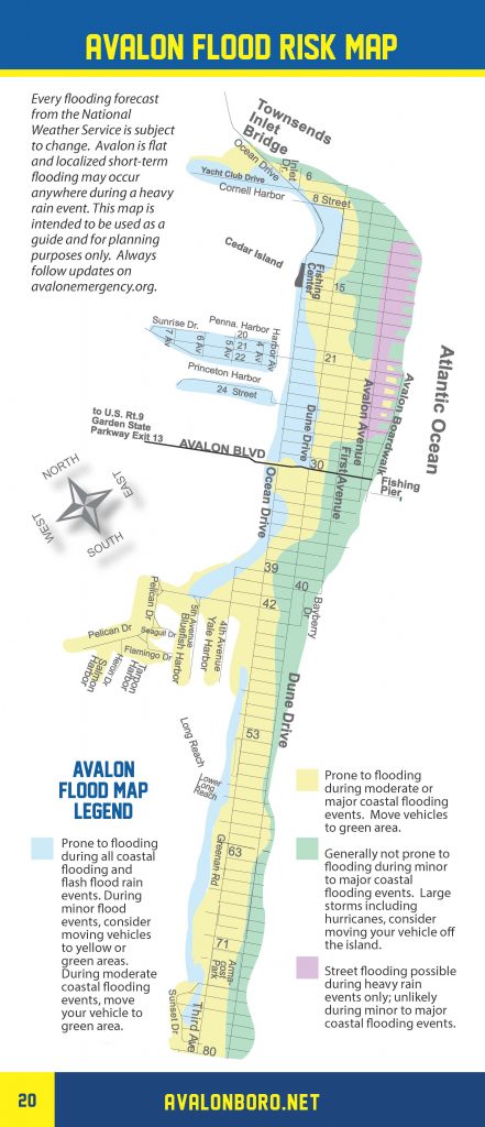
Avalon has prepared a flood risk map that shows areas that are at-risk during flooding events:

Avalon’s Flood Risk Map
Here is the text of the Coastal Flood Watch issued by the National Weather Service:
Coastal Flood Watch
Coastal Hazard Message
National Weather Service Mount Holly NJ
457 AM EDT Fri Apr 3 2020
NJZ021>025-032200-
/O.NEW.KPHI.CF.A.0001.200404T0600Z-200404T1400Z/
Cumberland-Atlantic-Cape May-Atlantic Coastal Cape May-
Coastal Atlantic-
457 AM EDT Fri Apr 3 2020
…COASTAL FLOOD WATCH IN EFFECT FROM LATE TONIGHT THROUGH
SATURDAY MORNING…
* WHAT…One to two feet of inundation above ground level
possible in low-lying areas near shorelines and tidal
waterways.
* WHERE…Cumberland, Atlantic, Cape May, Atlantic Coastal Cape
May and Coastal Atlantic.
* WHEN…From late tonight through Saturday morning.
* IMPACTS…At this level, widespread flooding of roadways is
expected with many roads becoming impassable. Lives may be at
risk when people put themselves in harm`s way. Some damage to
vulnerable structures may begin to occur. In Cumberland County,
minor roadway flooding is possible in Fortescue, Money Island,
Gandys Beach and other locations near the Delaware Bay
shoreline.
PRECAUTIONARY/PREPAREDNESS ACTIONS…
A Coastal Flood Watch means that conditions favorable for
flooding are expected to develop.
Be prepared to begin taking appropriate action to protect life
and property. Follow the recommendations of local emergency
management officials. Be sure to check the latest forecast from
time to time in case a warning is issued or any new information
becomes available.
Visit the Advanced Hydrologic Prediction Service at
water.weather.gov/ahps for additional water level and flood
impact information for your local tide gauge.


