The National Weather Service has issued a Flash Flood Watch for Avalon and the rest of southern New Jersey due to a developing low pressure system that is expected to move up the eastern seaboard over the next 48 hours. This system may become a tropical system and could bring heavy rain, wind, rip currents, and some coastal flooding to our community.
The Flash Flood Watch is in effect at midnight on Friday, July 10th through 4:00pm, on July 10th. There is the potential for one to three inches of rain, with higher amounts possible, during this storm. Heavy rain may occur in a brief period of time which can cause street flooding until the rain water drains from the streets. Never drive on a flooded street or through a flooded intersection as this puts you and your vehicle at risk, and causes an unnecessary wake that can damage property.
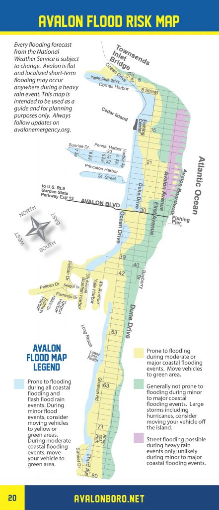
Of particular importance is the threat to Avalon’s north end beach blocks. This area may flood during times of heavy rainfall in a short period of time. Residents and visitors to the north end beach blocks should consider moving their vehicles to another part of Avalon that typically does not flood during heavy rainfall events.

Avalon’s Flood Risk Map
The Avalon Office of Emergency Management is in continual contact with the Cape May County Office of Emergency Management and New Jersey State Police regarding this weather event. Continue to monitor our media channels and traditional media outlets for updates when necessary


