

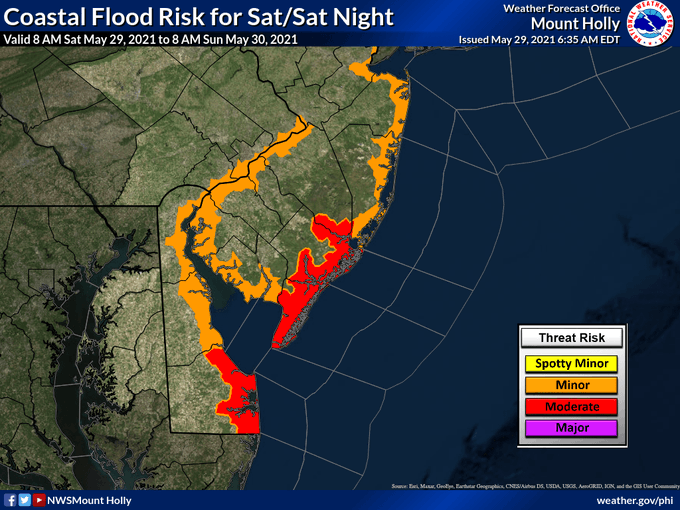
The National Weather Service has issued a Coastal Flood Warning for the Borough of Avalon and the Jersey Shore in advance of the high tide Saturday night, May 29th. There is the risk of moderate coastal flooding in flood prone areas of our community.
A coastal storm continues to impact our region with windy conditions, and periods of heavy rain. There are two high tide events for Saturday, at 11:12am and again at 11:33pm. Tidal flooding is expected, especially during tonight’s high tide.
Portions of Ocean Drive, the Dune Drive business district, and areas closer to the bay in Avalon could receive flooding this evening.
If you live, or are staying, in a section of Avalon that is prone to tidal flooding, consider moving your vehicle to another section of the community that is not prone to flooding. Avalon provides a flood risk map that is helpful for you to make a decision. Never drive on a flooded street. This puts you and your vehicle at risk and the wake causes damage to private and public property. Turn around, don’t drown.
![]()
Access to the Townsend’s Inlet Bridge between Avalon and Sea Isle City will be closed due to rough surf conditions in the inlet at times over the next 24 hours. The Ingram’s Thorofare Bridge remains your best option to leave the island. The Avalon Beach Patrol is restricting access to the surf due to unsafe conditions and strong rip currents.
Here is the text of the Coastal Flood Warning from the National Weather Service:
…HIGH RIP CURRENT RISK REMAINS IN EFFECT THROUGH SUNDAY
EVENING…
…COASTAL FLOOD WARNING REMAINS IN EFFECT FROM 9 PM THIS EVENING
TO 5 AM EDT SUNDAY…
* WHAT…For the Coastal Flood Warning, one to two feet of
inundation above ground level expected in low-lying areas near
shorelines and tidal waterways. For the High Rip Current Risk,
dangerous rip currents expected.
* WHERE…Atlantic Coastal Cape May and Coastal Atlantic.
* WHEN…For the Coastal Flood Warning, from 9 PM this evening
to 5 AM EDT Sunday. For the High Rip Current Risk, through
Sunday evening.
* IMPACTS…At this level, widespread roadway flooding occurs in
coastal and bayside communities and along inland tidal
waterways. Many roads become impassable. Some damage to
vulnerable structures may begin to occur. Rip currents can
sweep even the best swimmers away from shore into deeper water.
PRECAUTIONARY/PREPAREDNESS ACTIONS…
A Coastal Flood Warning means that moderate or major tidal
flooding is occurring or imminent. Be prepared for rising water
levels and take appropriate action to protect life and property.
Follow the recommendations of local emergency management
officials.
Do not drive your vehicle through flood waters. The water may be
deeper than you think it is. You will be putting yourself in
danger and your vehicle may be damaged, leading to costly
repairs.
Visit the Advanced Hydrologic Prediction Service at
water.weather.gov/ahps for additional water level and flood
impact information for your local tide gauge.
Entering the surf is discouraged. If caught in a rip current,
relax and float. Don`t swim against the current. If able, swim in
a direction following the shoreline. If unable to escape, face
the shore and call or wave for help.
