BREAKING NEWS
Sunday, March 24th, 3:46pm: Coastal Flood Warning for Monday-Tuesday, March 25-26th

The National Weather Service has issued a Coastal Flood Warning for Avalon and the southern coastal region of New Jersey. The warning is in effect from Monday, March 25th at 6:00am through Tuesday, March 26th, at 2:00pm. Minor tidal flooding is likely at time of high tide Monday morning. The highest water levels are expected during the Monday evening and Tuesday morning high tide events.
High tide will occur at the Townsend’s Inlet Bridge Monday at 2:52am and again at 9:20pm. High tide will occur Tuesday at 3:28pm and again at 9:51pm.
Please exercise caution while driving during times of high tide during the Coastal Flood Warning. Never drive on any street that is covered in tidal water as this puts you and your vehicle at risk and may flood other vehicles and properties. Avalon has developed a flood risk map for our community. Please use this map as a guide in the event you want to move your vehicle to another part of the community that is not prone to tidal flooding. The weather forecast will be dry and breezy during this flooding event.
![]()
Here is the text of the Coastal Flood Warning issued by the National Weather Service:
Coastal Flood Warning
Coastal Hazard Message
National Weather Service Mount Holly NJ
329 PM EDT Sun Mar 24 2024
…COASTAL FLOOD WARNING IN EFFECT FROM 6 AM MONDAY TO 2 PM EDT
TUESDAY…
* WHAT…One to two feet of inundation above ground level
expected in low-lying areas near shorelines and tidal
waterways.
* WHERE…Ocean, Atlantic, Cape May, Atlantic Coastal Cape May,
Coastal Atlantic, Coastal Ocean and Southeastern Burlington.
* WHEN…From 6 AM Monday to 2 PM EDT Tuesday.
* IMPACTS…At this level, widespread roadway flooding occurs in
coastal and bayside communities and along inland tidal
waterways. Many roads become impassable. Some damage to
vulnerable structures may begin to occur.
* ADDITIONAL DETAILS…Widespread minor flooding is likely with
the Monday morning high tide, but the highest water levels are
expected with the Monday evening and Tuesday morning high tides.
PRECAUTIONARY/PREPAREDNESS ACTIONS…
Take the necessary actions to protect flood-prone property. If
travel is required, do not drive around barricades or through
water of unknown depth.
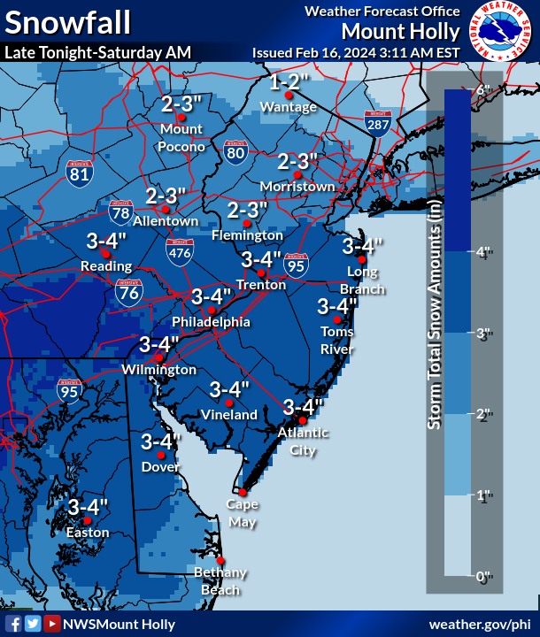
Friday, February 16th: Winter Weather Advisory in Effect Through Saturday Morning
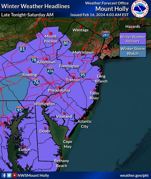
Winter Weather Advisory
URGENT – WINTER WEATHER MESSAGE
National Weather Service Mount Holly NJ
546 AM EST Fri Feb 16 2024
DEZ001-002-MDZ012-015-019-020-NJZ016>019-021>023-027-PAZ070-071-
101-102-104-170000-
/O.CON.KPHI.WW.Y.0007.240217T0300Z-240217T1500Z/
New Castle-Kent-Kent MD-Queen Annes-Talbot-Caroline-Salem-
Gloucester-Camden-Northwestern Burlington-Cumberland-Atlantic-
Cape May-Southeastern Burlington-Delaware-Philadelphia-
Western Chester-Eastern Chester-Eastern Montgomery-
Including the cities of Wilmington, Dover, Chestertown,
Centreville, Easton, Denton, Pennsville, Glassboro, Camden,
Cherry Hill, Moorestown, Mount Holly, Millville, Hammonton,
Cape May Court House, Wharton State Forest, Media, Philadelphia,
Honey Brook, Oxford, West Chester, Kennett Square, Norristown,
and Lansdale
546 AM EST Fri Feb 16 2024
…WINTER WEATHER ADVISORY REMAINS IN EFFECT FROM 10 PM THIS
EVENING TO 10 AM EST SATURDAY…
* WHAT…Snow expected. Total snow accumulations of 2 to 5
inches.
* WHERE…Portions of central and northern Delaware, northeast
Maryland, southern New Jersey and southeast Pennsylvania.
* WHEN…From 10 PM this evening to 10 AM EST Saturday.
* IMPACTS…Plan on slippery road conditions.
* ADDITIONAL DETAILS…Snow may briefly become heavy late tonight
before tapering off early Saturday.
Sunday, February 11th: Coastal Flood Warning Issued for Avalon February 12-14th
The National Weather Service has issued a Coastal Flood Warning for Avalon. The Warning is in effect as a winter storm approaches that will bring some rain to the Jersey Shore, but snow far north and west of our area. The Coastal Flood Warning is in effect from Monday, February 12th at 8:00am through Wednesday, February 14th, at 3:00am.
Minor tidal flooding is expected at time of high tide Monday through Tuesday night. As this large storm leaves the mid-Atlantic region, moderate tidal flooding is possible at time of high tide Tuesday night. Monday’s high tides will occur at 9:38am and 10:07pm; Tuesday’s high tides will occur at 10:27am and 10:58am; and Wednesday’s high tides will occur at 11:19am and again at 11:53pm.
Never drive on any street that has tidal flooding as this puts you and your vehicle at risk. Avalon has produced a flood risk map the shows where tidal flooding may occur during minor and moderate tidal flooding events.
Rain is expected in our area Monday night after sunset through lunchtime on Tuesday.
![]()
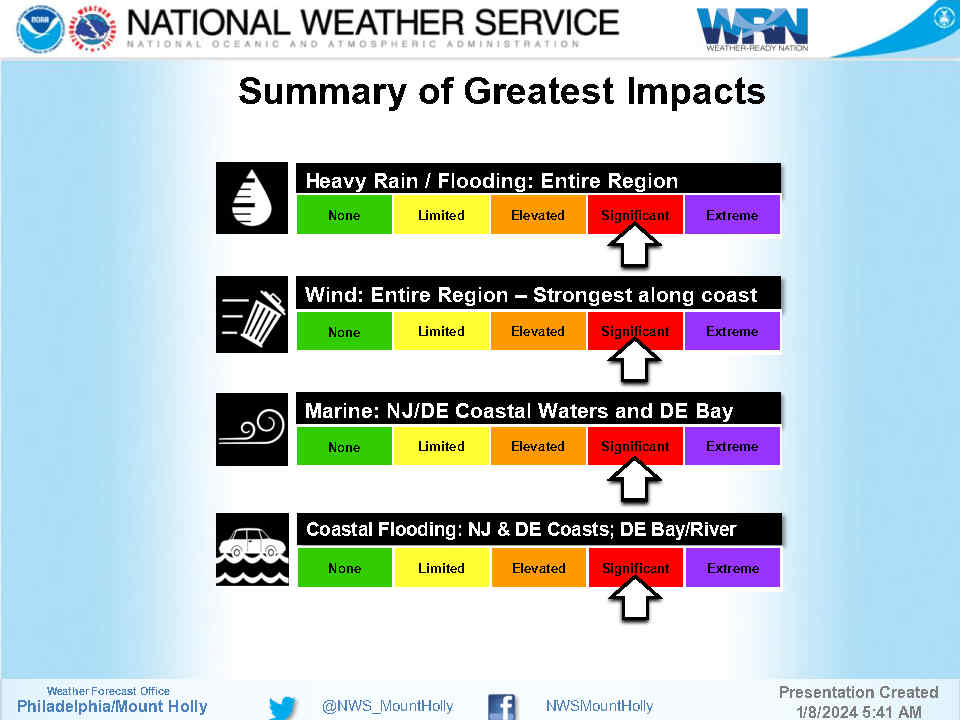
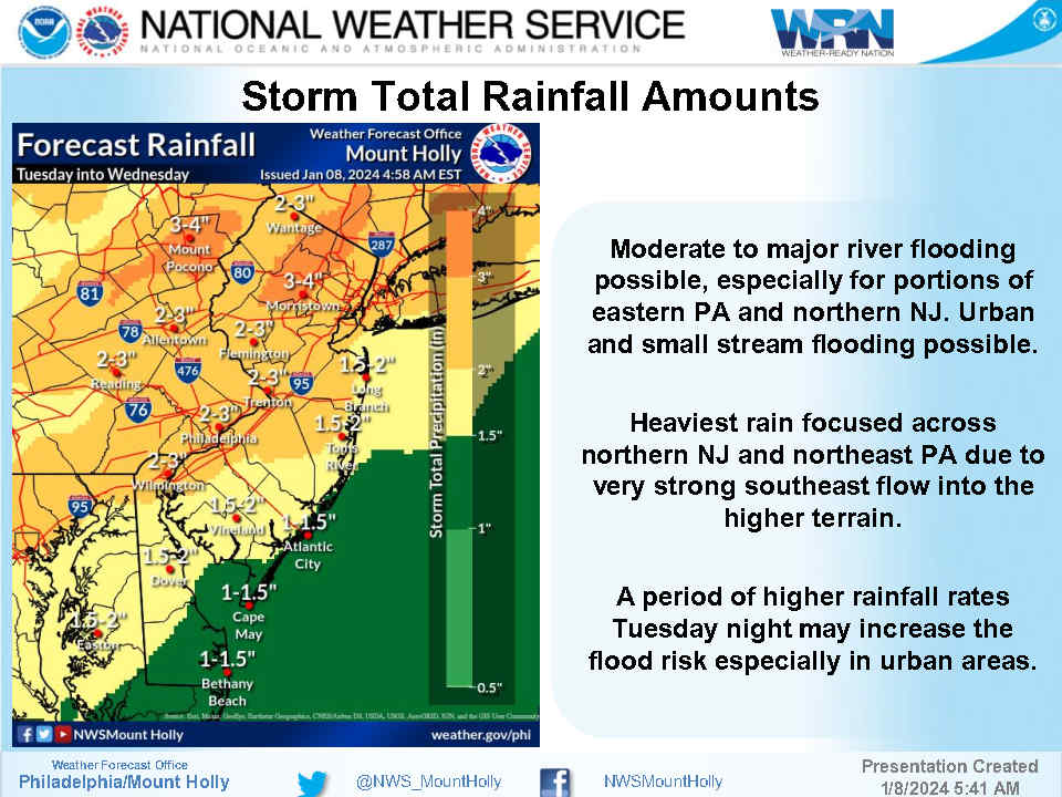
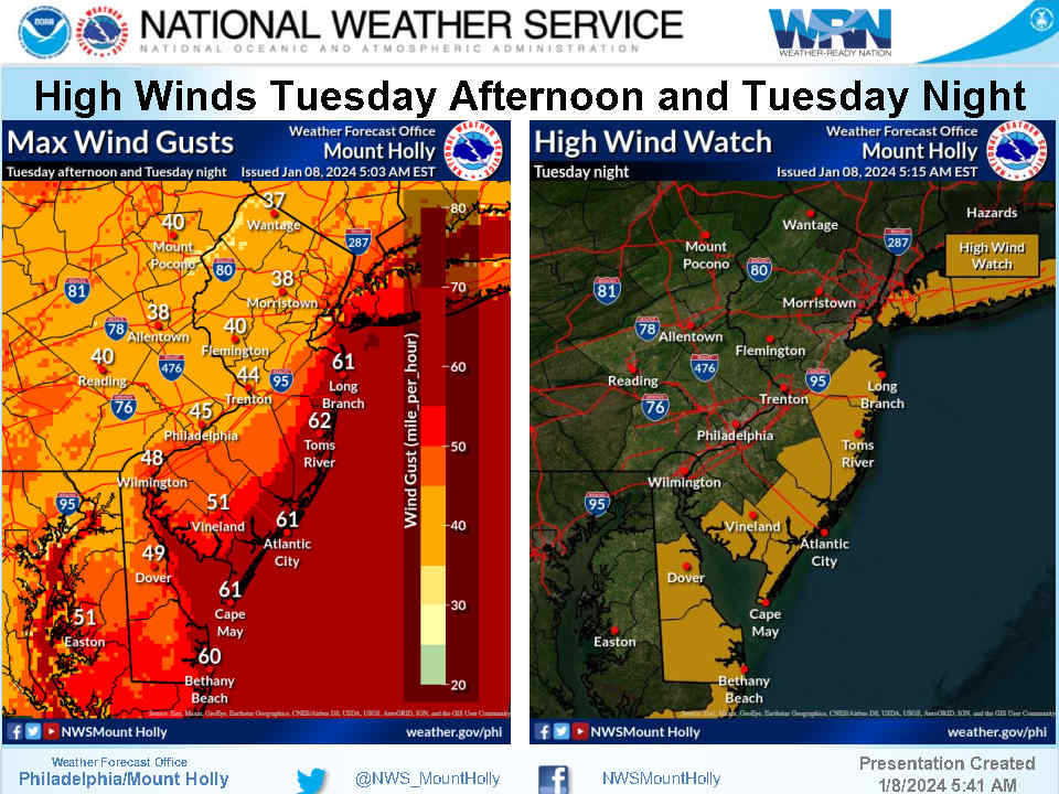
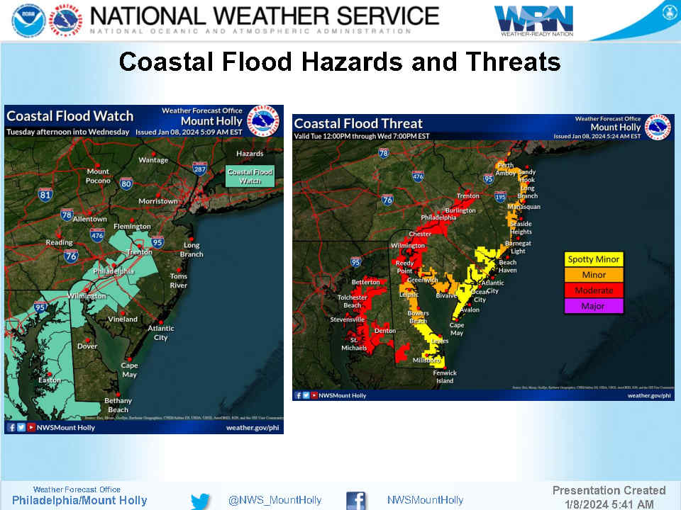
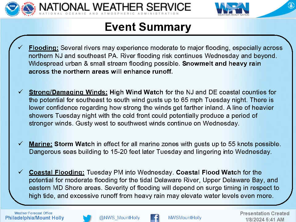
Monday, January 8th: Coastal Storm to Bring Very Strong Winds, Rain, Tidal Flooding Tuesday-Tuesday Evening
The National Weather Service has issued a High Wind Watch and a Flood Watch for Avalon and our entire region. A storm system will arrive Tuesday afternoon and bring heavy rain, very strong winds, and the potential for minor tidal flooding. Wind gusts in our region could surpass 60mph. You are encouraged to secure outdoor objects in advance of this storm; contractors are encouraged to secure job sites late Monday and Tuesday morning. High tide will occur at the Townsend’s Inlet Bridge Tuesday at 6:15pm, and again Wednesday at 6:43am. Be advised strong winds may close access roads to the bridge Tuesday night. If you have any emergency, dial 911. If you have a power outage, contact Atlantic City Electric directly at 1-800-833-7476. Please pay attention to future alerts and the weather forecast as we get closer to this storm event.
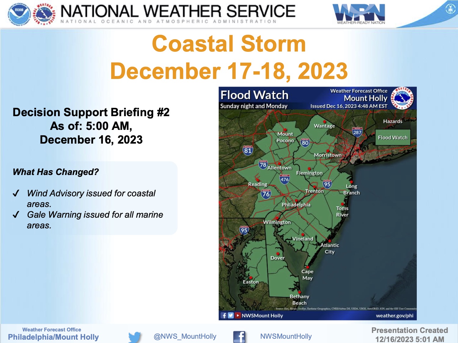
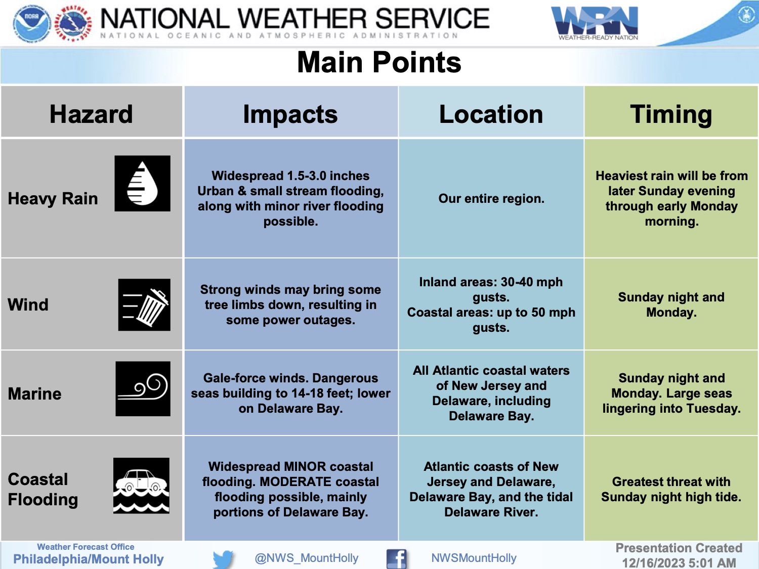
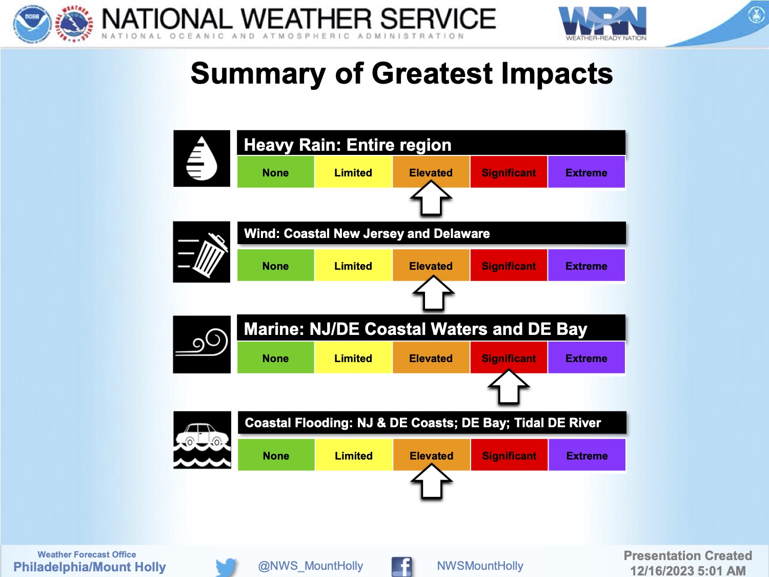
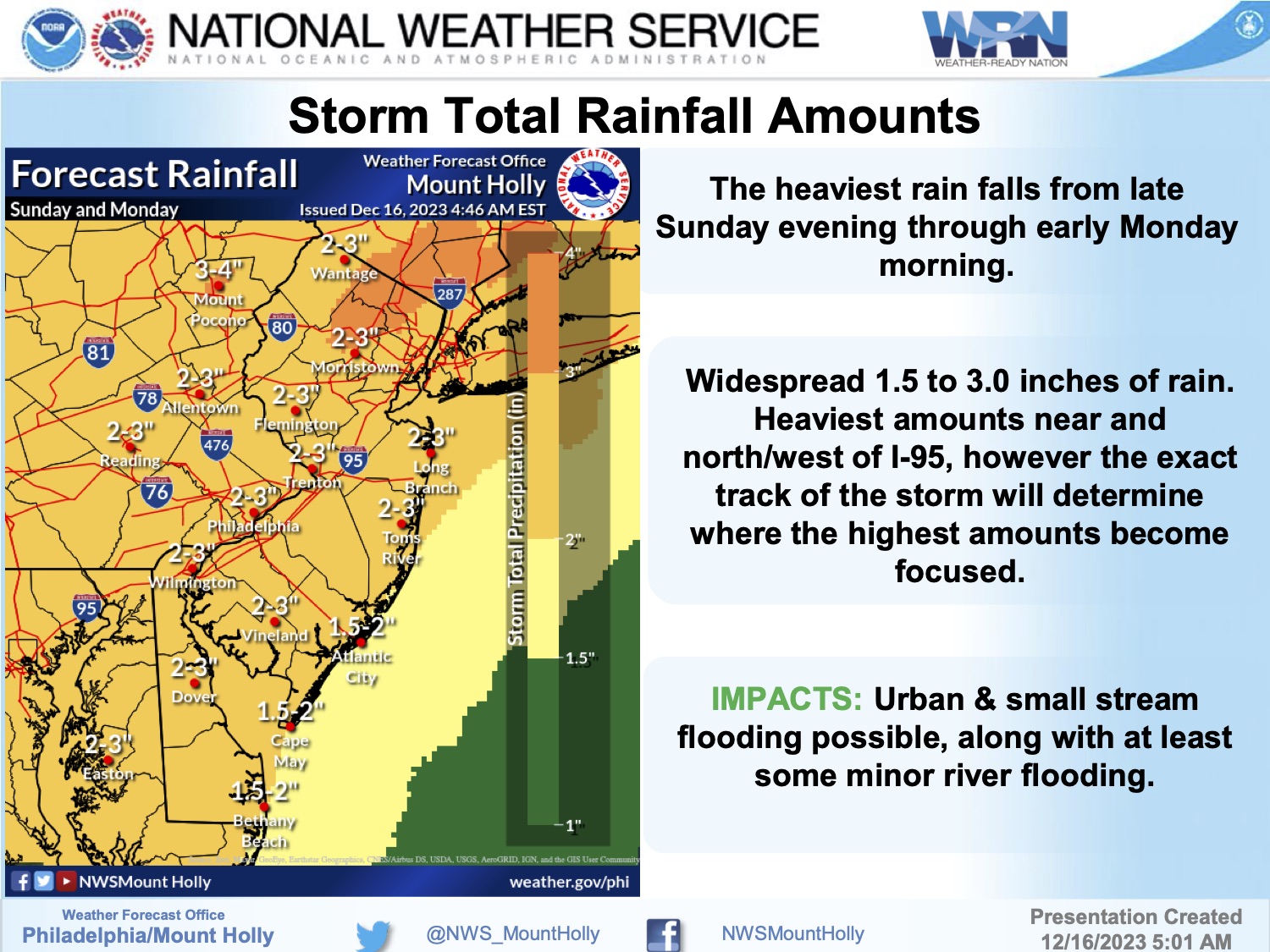
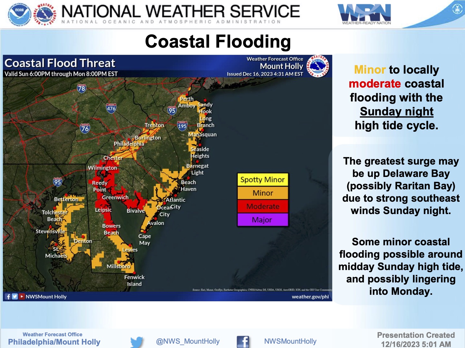
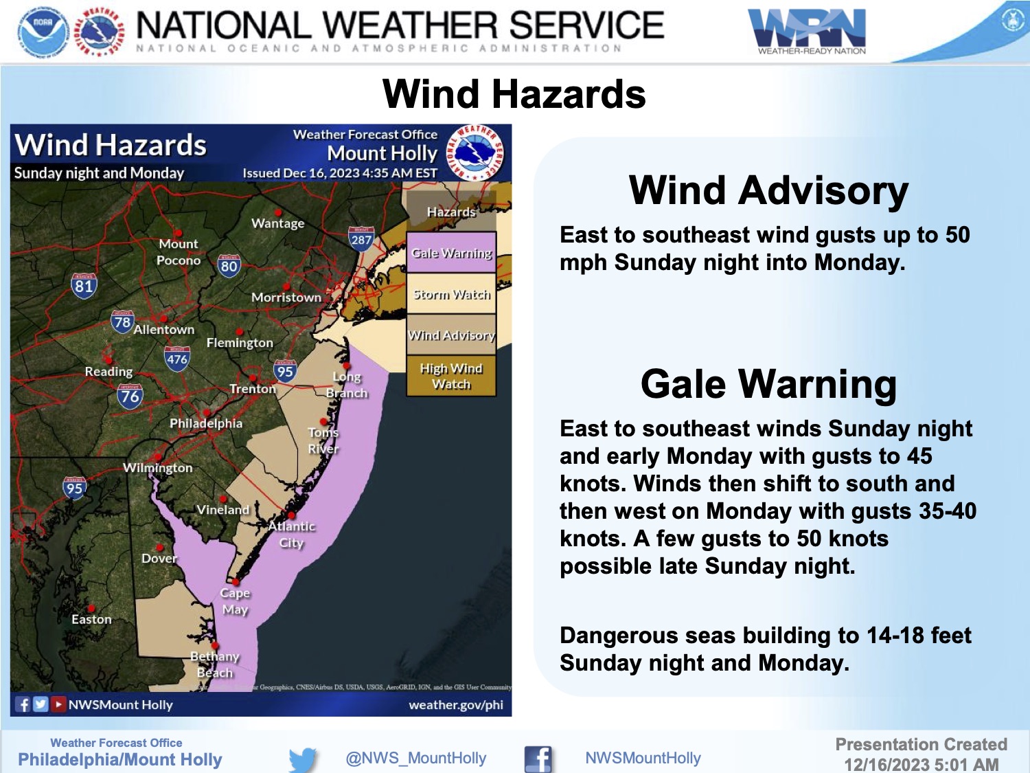
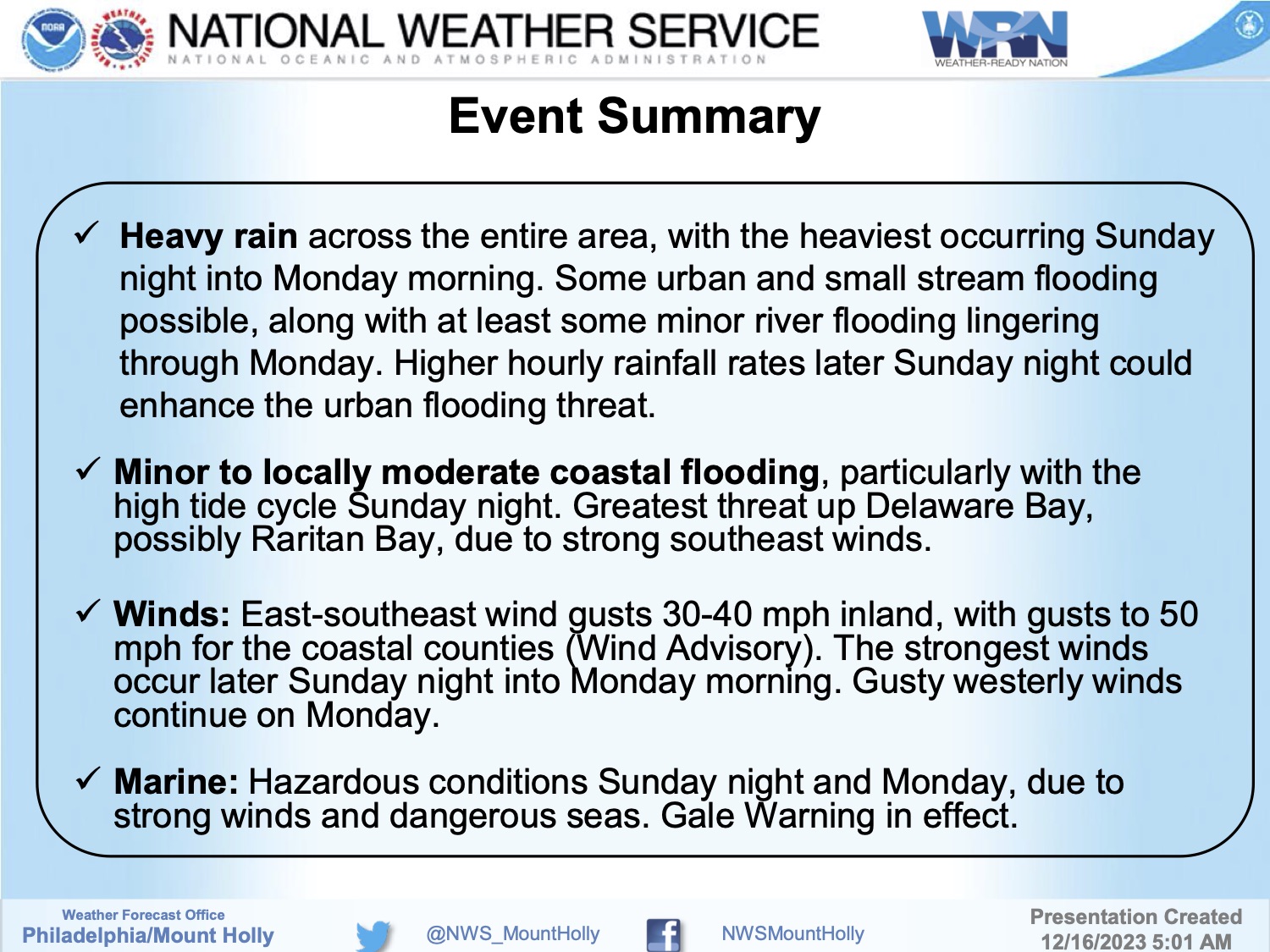
Saturday, December 16th, 8:03am: Nor’easter to Impact Avalon Sunday Night-Monday Morning
The National Weather Service has issued a Flood Watch and a Wind Advisory for Avalon for an approaching coastal storm that will impact our region Sunday night. The Flood Watch runs from Sunday evening through Monday afternoon, December 17-18th. Street flooding is possible due to heavy rainfall; some minor tidal flooding may also occur. The Wind Advisory is in effect Sunday evening through Monday morning with easterly winds gusting towards 50mph. High tide at the Townsend’s Inlet Bridge will occur Sunday at 11:45pm, and again Monday at 12:04pm.
It is advisable to secure any outdoor objects, including patio furniture and holiday decorations. Residents who live in areas of Avalon prone to rainfall flooding should consider moving their vehicles to areas of Avalon that do not experience this flooding in advance of Sunday evening. Avalon has produced a color-coded map indicating these areas in lavender. If you have any emergency, dial 911. Please see the Avalon flood map and the briefing package prepared by National Weather Service/Mt. Holly.
![]()
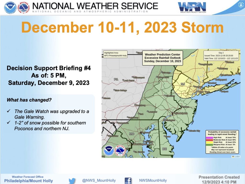
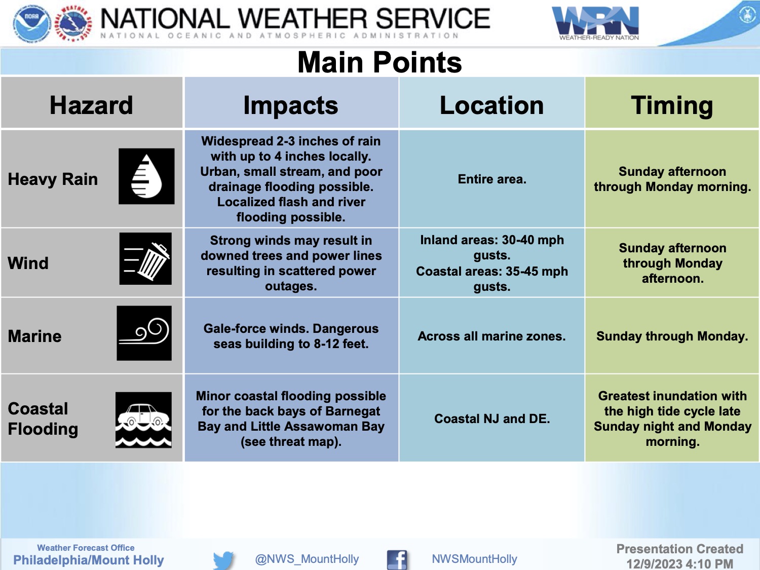
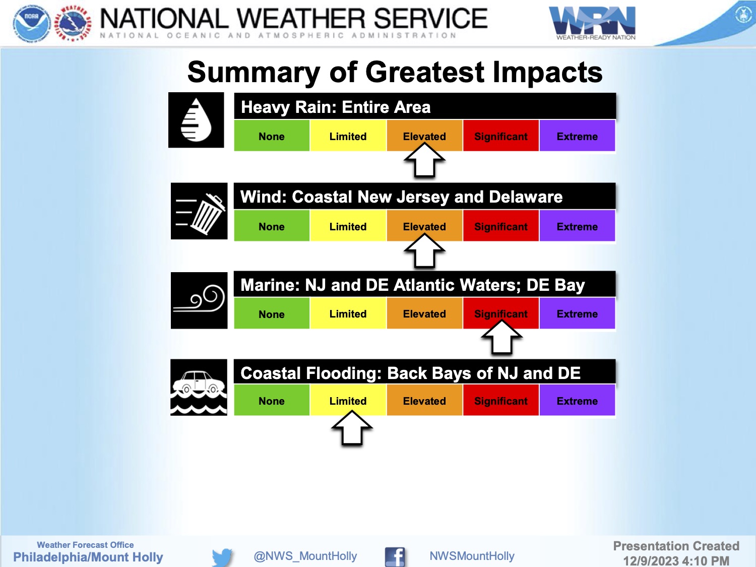
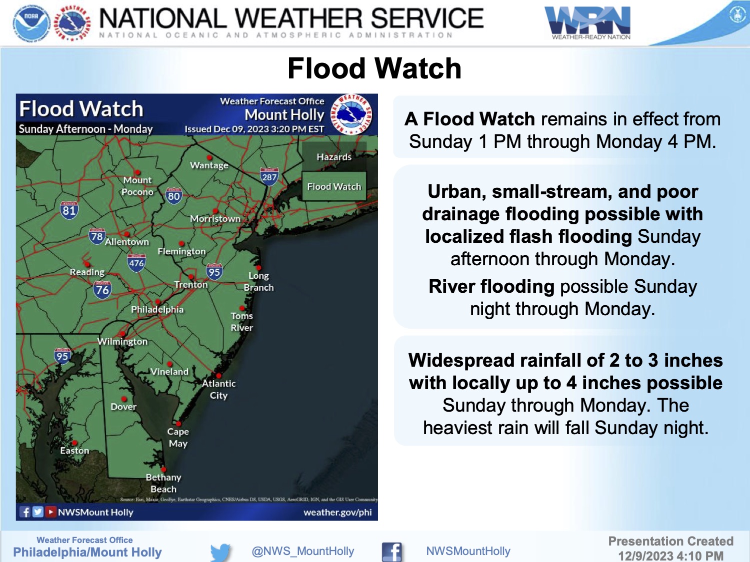
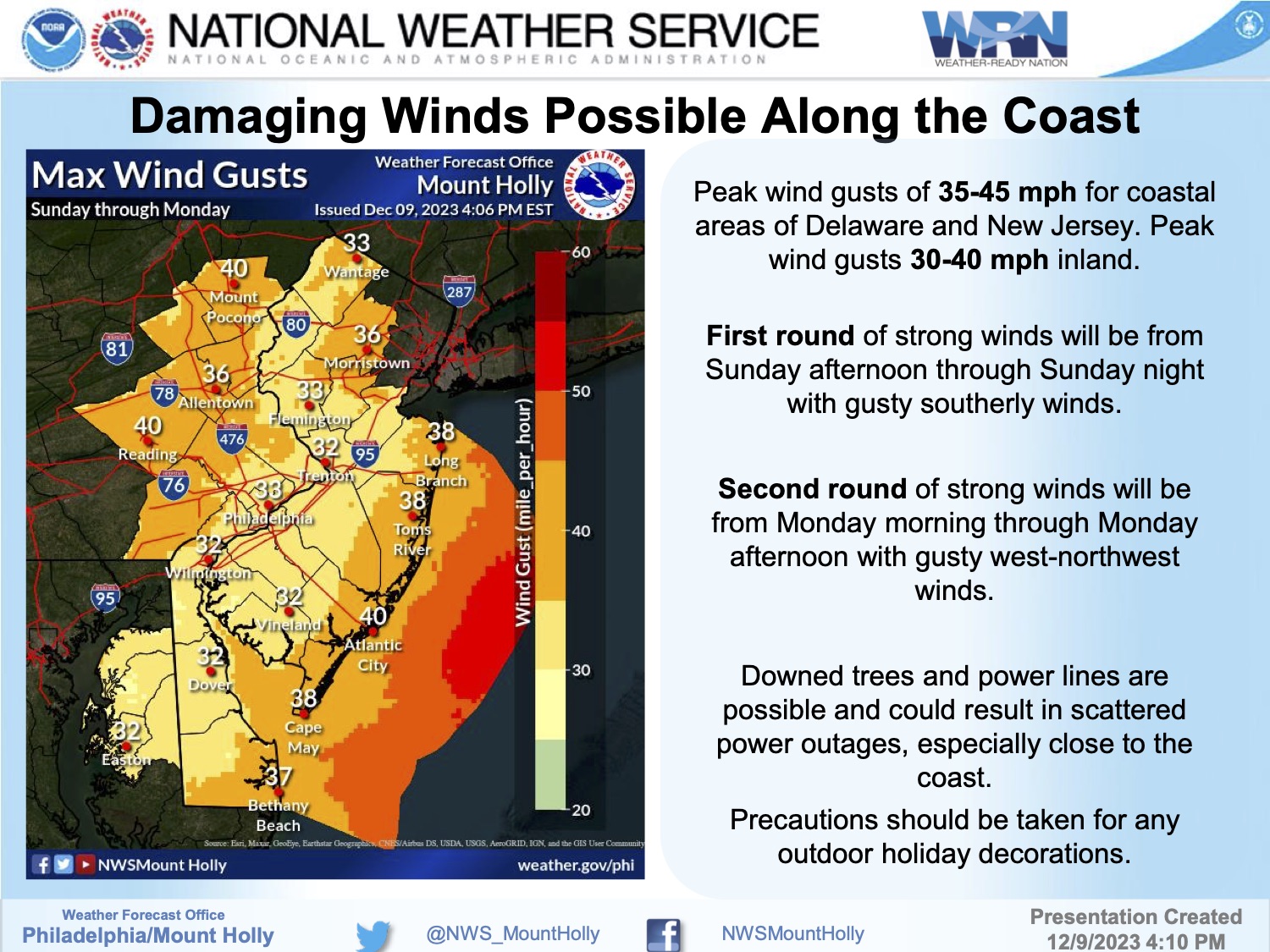
Saturday, December 9th: 2-3″ of Rain, Strong Winds Anticipated Sunday Night into Monday
The National Weather Service has issued a Flood Watch for Avalon. The Flood Watch is in effect from Sunday, December 10th, at 1:00pm through Monday, December 11th, at 4:00pm. Significant rainfall, up to three inches, is expected during a storm event late Sunday afternoon into early Monday morning. Tidal flooding is not expected from this storm. However, excessive rainfall could make driving impossible in certain sections of our community after sunset on Sunday. Northern Avalon beach blocks are prone to flooding during excessive rainfall, along with sections of the Dune Drive business district. Do not leave your vehicle in the street in these areas during this storm event; consider moving your vehicle to another part of Avalon that does not flood during excessive rainfall. Avalon has produced a flood risk map that shows these areas in light purple, posted below.
Strong winds are expected along the coast of up to 40mph. Please secure loose outdoor objects, including patio furniture, in advance of this storm event.
If you have any emergency at any time, please call 911.
Avalon’s Flood Risk Map