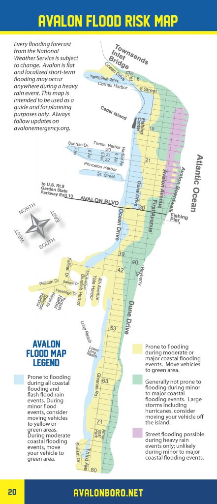
The National Weather Service has continued the Coastal Flood Warning for our community for the high tide during the evening hours of Monday, September 10th. Moderate coastal flooding is possible at time of high tide, which will occur at 9:24pm at the Townsend’s Inlet Bridge.
We have experienced some flooding on flood prone streets during the past few high tide cycles; flooding is expected during high tide this evening. Please exercise caution while driving and never drive on a flooded street. Doing so puts you and your vehicle at risk and creates a wake that can damage your vehicle, along with public and private property.
Sections of Dune Drive in the business district and sections of Ocean Drive may see moderate flooding this evening. High tide will occur during the nighttime hours so it may be difficult to see a flooded street.
This may be the final flood warning during this storm event. The Avalon Office of Emergency Management participated in a conference call today with the Cape May County Office of Emergency Management regarding the potential impacts from Hurricane Florence. The current track of Florence predicts a landfall in the southern portion of North Carolina later this week. Continue to monitor the forecast for updates.
Here is the text of the Coastal Flood Warning issued by the National Weather Service:
Coastal Flood Warning
Coastal Hazard Message National Weather Service Mount Holly NJ 408 PM EDT Mon Sep 10 2018
Delaware Beaches-Atlantic Coastal Cape May-Coastal Atlantic- 408 PM EDT Mon Sep 10 2018
…HIGH SURF ADVISORY NOW IN EFFECT UNTIL 5 AM EDT TUESDAY… …HIGH RIP CURRENT RISK NOW IN EFFECT THROUGH TUESDAY EVENING… …COASTAL FLOOD WARNING IN EFFECT UNTIL 2 AM EDT TUESDAY… The National Weather Service in Mount Holly has issued a Coastal Flood Warning, which is in effect until 2:00 AM Tuesday.
* LOCATIONS…Coastal areas of the New Jersey counties of Atlantic and Cape May, and Sussex County in Delaware.
* TIMING…High tide on the New Jersey and Delaware oceanfront occurs between 8:30 PM and 9:30 PM this evening. High tide on the back bays and along Delaware Bay occurs later than the high tide on the oceanfront.
* COASTAL FLOOD IMPACTS…One to two feet of saltwater inundation above ground level is possible in low-lying areas near shorelines and tidal waterways. Widespread flooding of roadways is expected with many roads becoming impassable. Lives may be at risk when people put themselves in harm`s way. Some damage to vulnerable structures may occur.
* RIP CURRENT RISK…High.
* SURF ZONE IMPACTS…Large breaking waves will be dangerous to anyone who enters the surf. Very strong rip currents will be life threatening to anyone who enters the surf.
* WAVES…Wave heights on the ocean waters off the coast are forecast to be around 10 to 12 feet.
PRECAUTIONARY/PREPAREDNESS ACTIONS… This Coastal Flood Warning means that moderate tidal flooding is occurring or imminent. Be prepared for rising water levels and take appropriate action to protect life and property. Follow the recommendations of local emergency management officials. Do not drive your vehicle through flood waters. The water may be deeper than you think it is. You will be putting yourself in danger and your vehicle may be damaged, leading to costly repairs. Visit the Advanced Hydrologic Prediction Service at water.weather.gov/ahps for additional water level and flood impact information for your local tide gauge. A High Surf Advisory means that high surf will affect beaches in the advisory area, producing localized beach erosion and dangerous swimming conditions.


