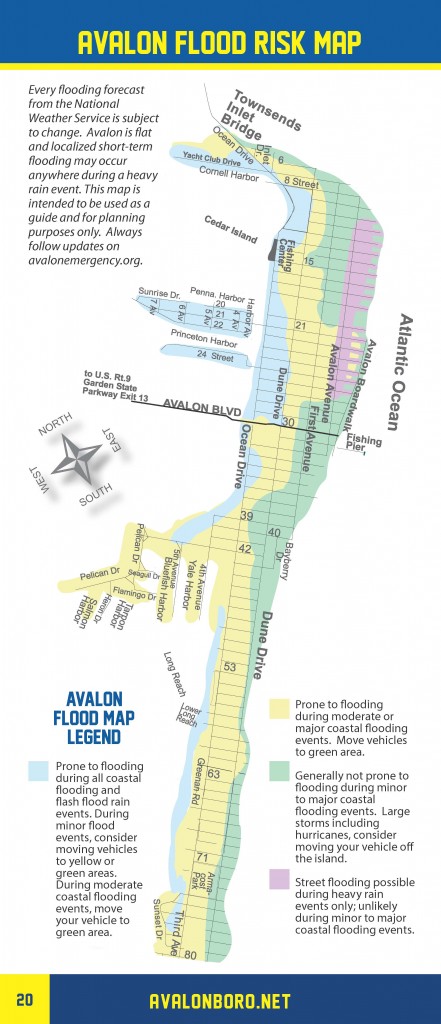
The National Weather Service has issued a Coastal Flood Warning for Avalon for Tuesday, September 26th, starting at 4:00pm. Moderate tidal flooding is expected at high tide which will occur at the Townsend’s Inlet Bridge at 6:16pm. This event is expected to be similar to Saturday afternoon’s high tide in Avalon. If you live in an area of Avalon that receives tidal flooding, consider moving your vehicle to higher ground. Never drive on a flooded street as this causes damage to your vehicle and may create a wake that damages private and public property. If you have any emergency, dial 911. Please observe Avalon’s flood risk map to see areas that may be impacted by flooding Tuesday evening.
Here is the text of the Coastal Flood Warning from the National Weather Service:
Coastal Flood Warning
Coastal Hazard Message
National Weather Service Mount Holly NJ
…COASTAL FLOOD WARNING IN EFFECT FROM 4 PM TUESDAY TO MIDNIGHT
EDT TUESDAY NIGHT…
* WHAT…One to two feet of inundation above ground level is
expected in low-lying areas near shorelines and tidal
waterways.
* WHERE…Tidal areas in the New Jersey counties of Atlantic and
Cape May.
* WHEN…From 4:00 PM Tuesday until midnight on Tuesday night.
* IMPACTS…At this level, widespread roadway flooding occurs in
coastal and bayside communities and along inland tidal
waterways. Many roads become impassable. Some damage to
vulnerable structures may begin to occur.
* ADDITIONAL DETAILS…Spotty minor tidal flooding may occur
through early Tuesday afternoon, with additional lingering minor
tidal flooding possible from late Tuesday night into Wednesday.
PRECAUTIONARY/PREPAREDNESS ACTIONS…
Take the necessary actions to protect flood-prone property. If
travel is required, do not drive around barricades or through
water of unknown depth.


