


The National Weather Service has issued both a Flood Watch and a Wind Advisory for Thursday, November 15th. An approaching coastal storm is expected to bring one to two inches of rain to our region, along with northeasterly winds at 25-35mph, with gusts to 50mph.
Rain from the storm is expected to be heaviest during the late morning and afternoon hours; the wind gusts are expected to be strongest during the mid afternoon through evening hours on Thursday.
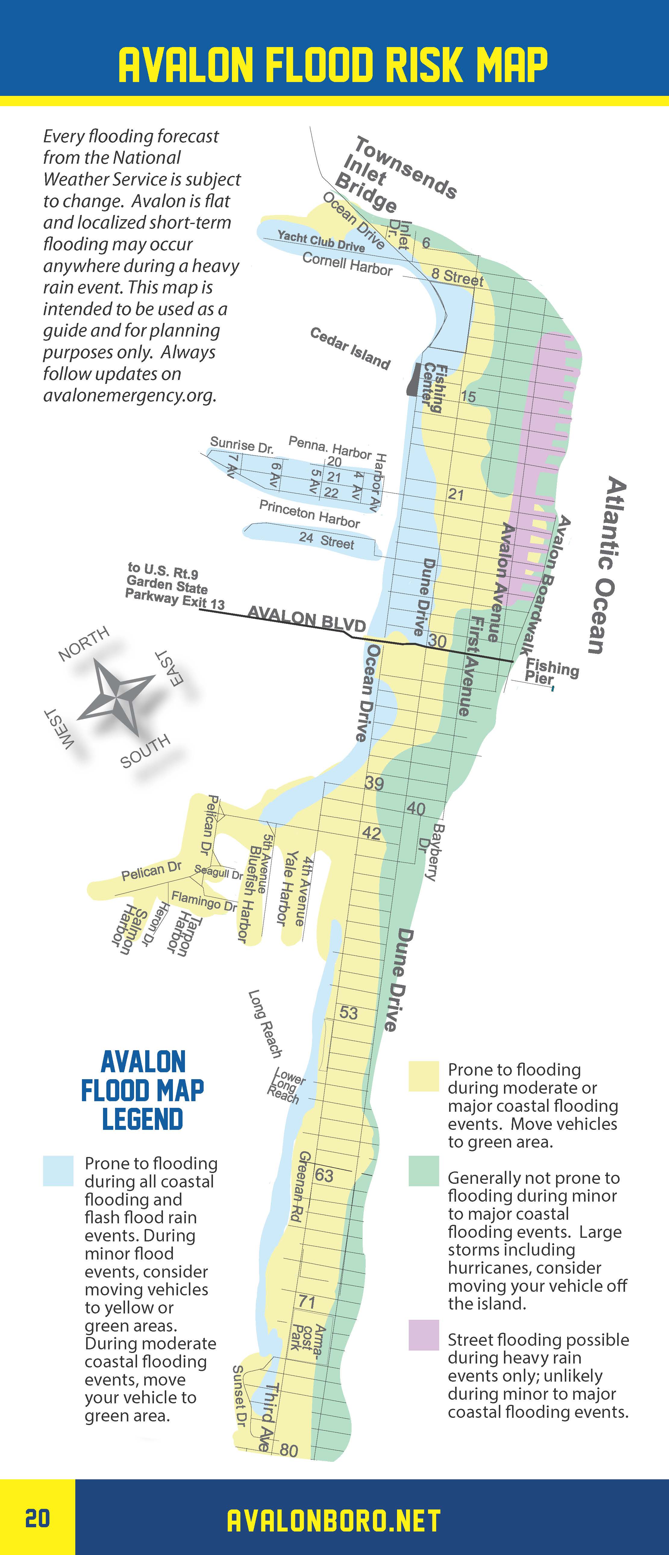
Tidal flooding is not expected, but flooding of local streets from rainfall may occur during the storm. Street flooding from rainfall typically occurs in the north end beach blocks; in the Dune Drive business district; and along sections of Ocean Drive in the Borough. Avoid driving your vehicle on any street that is flooded. Turn around, don’t drown. Driving on a flooded street can cause damage to, and inside garages and businesses easily avoided by you taking a different route.
Secure any objects that may become airborne on your property, including construction sites, patio furniture and trash cans. If you have any emergency, dial 911.
Here is the text of the Flood Watch and the Wind Advisory, both issued by the National Weather Service:
Flood Watch
Flood Watch National Weather Service Mount Holly NJ 245 AM EST Thu Nov 15 2018
FLOOD WATCH IN EFFECT FROM 10 AM EST THIS MORNING THROUGH THIS EVENING…
The National Weather Service in Mount Holly has issued a * Flood Watch for portions of eastern Maryland, central and southern Delaware, and southern New Jersey.
* From 10:00 AM this morning through this evening. * An area of heavy rain will lift northward across the region today. Rainfall totals of 1 to 2 inches are expected with locally higher amounts possible.
* The heavy rain will result in minor flooding along some rivers, streams and creeks in the area. Flooding of roadways and areas of poor drainage is also expected, especially as leaves and other debris clog storm drains.
PRECAUTIONARY/PREPAREDNESS ACTIONS… A Flood Watch means that there is the potential for flooding based on the current forecast. Please monitor the forecast and be alert for possible Flood Warnings. If you live in an area that is prone to flooding, be prepared to take action if flooding develops.
Wind Advisory
URGENT – WEATHER MESSAGE National Weather Service Mount Holly NJ 254 AM EST Thu Nov 15 2018 …WIND ADVISORY REMAINS IN EFFECT FROM 1 PM THIS AFTERNOON TO 11 PM EST THIS EVENING… * WINDS…East to northeast increasing to 25 to 35 mph with gusts up to 50 mph. * TIMING…The strongest winds are expected this afternoon into this evening. The winds should diminish somewhat late tonight, before increasing again from the northwest and west early on Friday. * IMPACTS…The strong winds may blow down trees, limbs and utility lines. Scattered power outages are expected. PRECAUTIONARY/PREPAREDNESS ACTIONS… A Wind Advisory means that very windy conditions are expected. The winds will make driving difficult, especially for those operating a large vehicle. Use extra caution. Light-weight outdoor objects such as patio furniture and garbage cans should be secured.
